Everybody heard of Berlin halved by the Cold War and Rome which is still divided between Italy and the Vatican. But do you know that there are two other European capitals with historical state borders cutting through their urban territory? One of them is Warsaw.
Our project is based in Warsaw. Our topic lies within the field of Habsburg history. This is somewhat atypical, as in our part of Europe the Austrian Monarchy is usually studied by scholars affiliated with institutions located within its old borders. In Ukraine, you will find most Habsburg historians in Lviv, not in Kyiv. In Italy, they will work in Triest rather than in Rome. In Poland, the bulk of them resides in Kraków, Rzeszów, and Wrocław (the latter has inherited the academic traditions of Polish Lviv). Of course, this rule is not waterproof, but it is the general tendency.
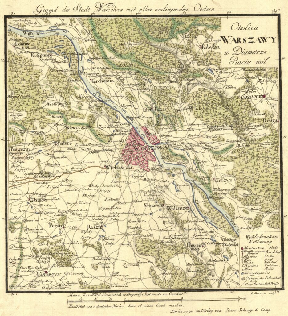
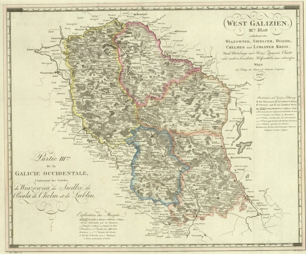
Austrian monarchs have never managed to extend their dominions to Warsaw. But at one point they came very close. In 1795 the Polish-Lithuanian Commonwealth was eventually partitioned and erased from the political map of Europe. Warsaw ended up under Prussian rule, becoming a Kammerdepartment centre in the province named Südpreußen (South Prussia). Its location was quite awkward for administrative purposes, as it lay on the very margins of its territorial jurisdiction. Less than thirty kilometres to the north, on the right bank of the river Bug (Zakhidnyi Buh in Ukrainian), started another Prussian province, Neuostpreußen (New East Prussia). Even more unusually, just a couple of kilometres to the east ran a state border separating the Prussian acquisitions from the Austrian ones, the so-called Westgalizien (West Galicia, sometimes called also Neugalizien). 1 This means, among others, that the first version of the famed Austrian Allgemeines bürgerliches Gesetzbuch was tested in the God-forsaken villages on the eastern outskirts of Warsaw long before it eventually came into force in Vienna. 2
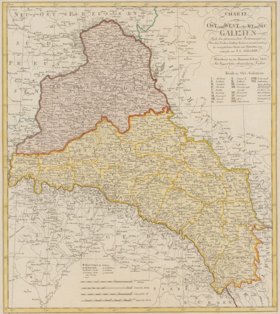
This arrangement did not last long: in 1807 Napoleon defeated Prussia and took the Süd- and Neuostpreußen from it, creating there his puppet Duchy of Warsaw (with the subservient king of Saxony as its duke). But the Austrian border stayed in place, so the newly independent duchy had its eponymous capital just a short walk from the dominions of a hostile power. Two years later, in 1809, Napoleon defeated Austria in the war of the fifth coalition and awarded Westgalizien to his Polish satellite, thus ending Warsaw’s stint as a border town and Austria’s neighbour. After Napoleon’s defeat Westgalizien was never restored to the Monarchy. Instead, the Congress of Vienna chose to transform the Duchy of Warsaw into a non-sovereign Kingdom of Poland, conjoined with the Russian Empire. Pushed back some two hundred kilometres to the south of the Polish capital by Napoleon, Austrian borders remained there for over a century.
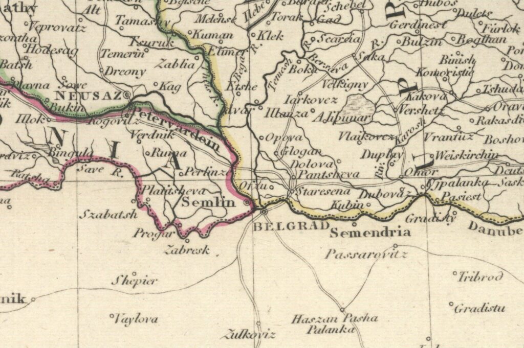
At the turn of the eighteenth and nineteenth centuries, Warsaw was a few kilometres away from the borderline, but since then the city limits have been gradually expanding (last changes took place only in the twenty-first century) and now a large section of the Austro-Prussian border cuts through the urban territory. Apart from Warsaw, there is only one other capital in Europe with a historical state border of the Austrian Monarchy running through it: it is Belgrade whose north-western district of Zemun (Semlin in German) used to be an Austrian border town, separated from the Serbian city by the river Sava. 3
Nowadays, on the eastern outskirts of Warsaw there are no easily discernible vestiges of the eighteenth-century Austrian presence. You will not find border stones with imperial eagles or anything like that: this boundary has been erased and forgotten. In the neighbourhood of Zielona, district of Wesoła, there used to be a neoclassicist building of the Austrian customs house, but it was demolished in 1944 by the German military (a paradox of sorts or perhaps not at all). 4
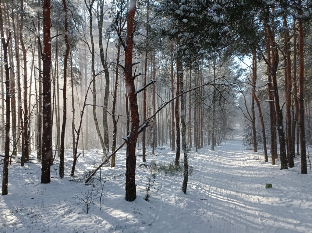
Although it is just a fifteen-minute ride by urban train from downtown Warsaw, tourists never visit this part of the city, devastated by the post-1989 urbanistic laissez-faire. It is, however, dotted with nice patches of woods, remnants of the forests that surrounded Warsaw at the time of the Austrian presence. Today, they attract young families seeking destinations for undemanding weekend walks. In one of such woods you may find the Wawerska street, an unassuming forest road.
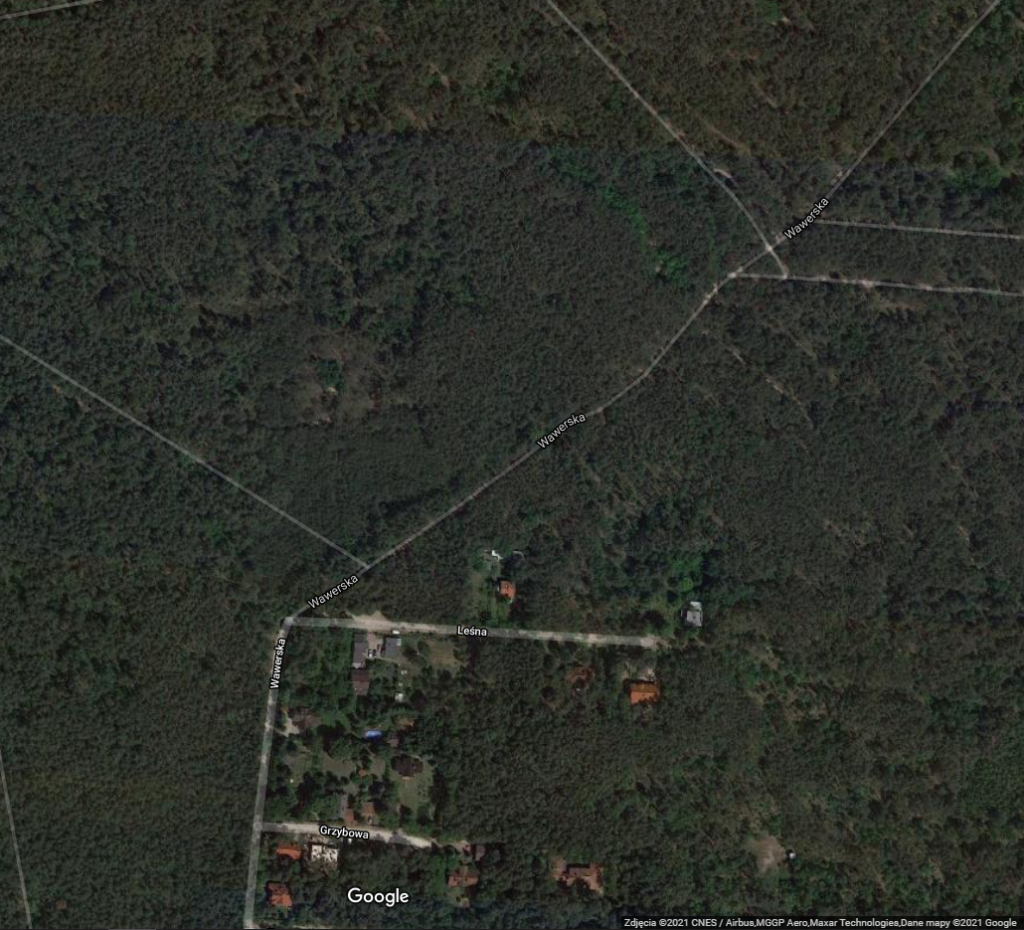
As it happens, this dirt road sets the boundary between two districts of Warsaw: Wawer and Wesoła. The district border in this area takes the shape of an acute bend.
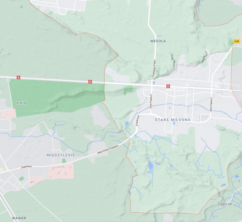
The district of Wesoła is composed of several neighbourhoods that used to be separate villages: the eponymous Wesoła, Zielona (the one where the customs house stood until 1944), Wola Grzybowska, and Miłosna, the oldest of all. They all lay on the Austrian side of the border. To the northwest of Miłosna the Austro-Prussian border made an acute bend, just like the one we know from today’s boundary between Wawer and Wesoła.
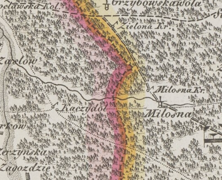
Now, I am not a land surveyor and I have not combed the archives for the Austro-Prussian delimitation protocols, but the two borders match each other closely and the present-day neighbourhoods should have inherited their boundaries from previous periods. Miłosna was the last locality on the Austrian side, so the western border of its grounds would have coincided with that of the Monarchy. It seems reasonable to assume that today’s western limit of the neighbourhood of Stara Miłosna, the unpaved Wawerska street, is the continuation of the eighteenth-century Austrian border. If you happen to be in Warsaw and you love Austrian history, you should not miss this place. Especially, when it is covered in snow. 5
⸻⸻⸻⸻⸻⸻⸻⸻⸻
1 See also this useful blog post in Polish: http://fenomenwarszawy.blogspot.com/2012/09/warszawa-miasto-nadgraniczne-cz-1.html (last retrieved 14 February 2021).
2 Austrian Allgemeines Bürgerliches Gesetzbuch was published in 1811. Its draft version was enacted in Neugalizien in 1797 as Bürgerliches Gesetzbuch von Westgalizien (published also in Polish as Ustawy cywilne dla Galicji Zachodniej) and extended to Altgalizien the following year.
3 I translate here the Austrian term Kreis, denoting a relatively small territorial unit, as district. I also use this English word for the Serbian gradska opština and the Polish dzielnica, a larger administrative division within the city, nowadays managed by locally elected officials (similar to the German Stadtbezirk and the French arrodissement). Neighbourhood stands for the Polish osiedle, a smaller area within the dzielnica.
4 The Austrian customs house is mentioned on the official website of the Wesoła district authorities: http://www.wesola.waw.pl/strona/historia (last retrieved 14 February 2021).
5 Avid early modernists may remember yet another episode when the Habsburgs came close to ruling over Warsaw. In 1587 a large part of the Polish-Lithuanian nobility elected Archduke Maximilian III of Austria as king. The other party, led by Chancellor Jan Zamoyski, supported Prince Stephen Báthory of Transylvania. The two sides fought a brief civil war which ended with the victory of the Zamoyski’s faction. Had Maximilian been more successful, he would have become an elective king for life, but even then the Polish-Lithuanian Commonwealth would have remained a separate polity, not a part of the Habsburg inheritance.
⸻⸻⸻⸻⸻⸻⸻⸻⸻
This is not an academic text sensu stricto. Its goal is to disseminate knowledge and to stimulate public interest in our field. The views and opinions expressed here are those of the author and do not necessarily reflect the official policy or position of either PAN or NCN.
One Reply to “When Warsaw was a town on the Austrian border”
Comments are closed.